Two Miles High, Part IV: The Mountain Is Our Father

Lakes, creeks, rocks, wildflowers, butterflies, marmots—and, of
course, mountains. The Alaska Basin Loop trail was, I announced, “a smorgasbord
of Tetonic delights.” It was also longer, and harder, than I had expected.
The trail was deceptive, climbing steadily, but never
steeply, for the first two miles. The haze had finally cleared, so the views
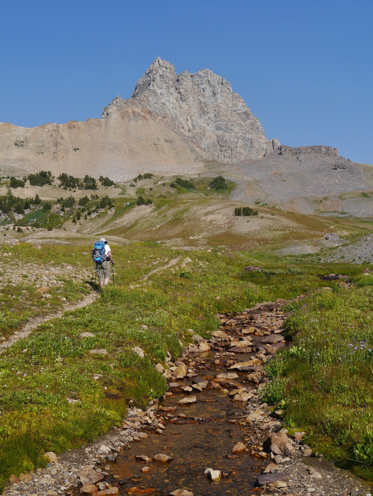
were astonishing. In fact, I took more than a hundred pictures over the course
of this four hour hike. We crossed shallow streams, rested on enormous boulders,
and climbed ever upward. Always before us was the craggy splendor of Buck
Mountain. “Wouldn’t it be cool to walk along the bottom of that mountain?”
asked Amy. I still wasn’t sure how close we’d get, but I agreed. And then,
after more than an hour of constant climbing, I caught a glimpse of where the
trail was taking us: to the very place where the basin ended and the mountain
began. We were going to find out just how cool it would be.

We stopped to rest and snack on trail max, and I took out
the map, looking more closely at the topographical markings. “Oh,” I said.
“What?” asked Amy.
“We’re going to be climbing up to—um—about 10,400 feet.”
“Oh,” she said.
We would be almost two miles above sea level, slightly
higher than if we’d climbed to Hurricane Pass. And I had sold this hike to her
as an easier one.

Altitude or not, it felt easier than a one-way slog up a
steep trail. We were carrying our backpacks, but had emptied them of all but
the ten essentials, so we were barely aware of them. And the grade was so
polite, so gentle, so unassuming that the thousand feet of elevation game was
almost a picnic. Note that I said “almost”; we were, after all, at the highest
altitude we would experience on this trip, a thousand feet higher than the
ridge we would’ve crossed to get to Alice Lake, and we were beginning to feel
it, mostly as a dull threat of a headache, a slight difficulty breathing. We
reached the apex of the hike, marveled at how close we were to this biggest of
rocks we would behold, and started down.
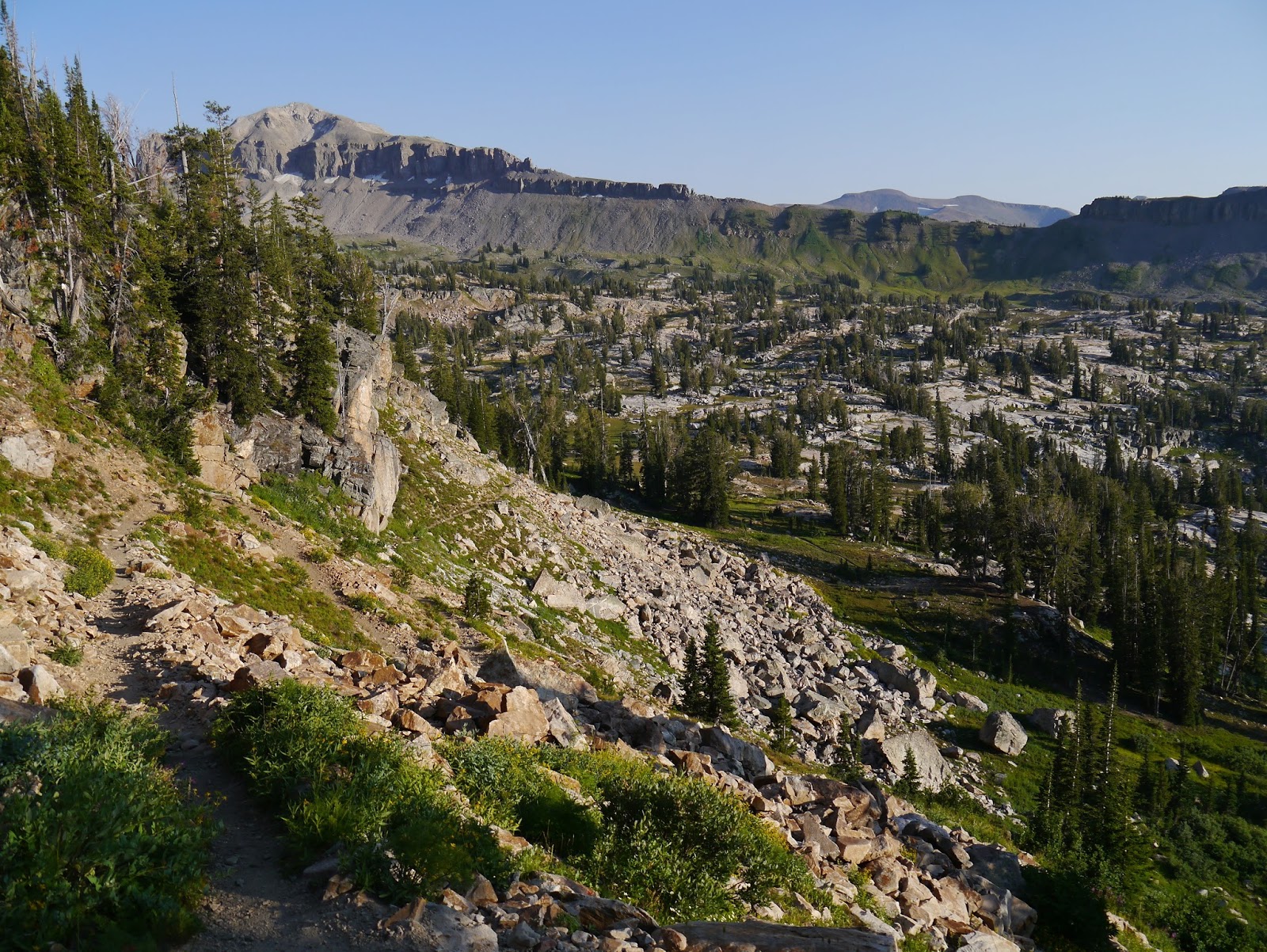
The grade was, again, gentle, but now we were beginning to
feel the miles, our feet aching, the headache becoming better defined. A family
of marmots distracted us, as did field upon field of brilliant wildflowers.
Every twist in the trail revealed another view, a fresh angle of the plateau
where we had slept the night before, the lakes of the basin, more fields of
flowers, and the ever-changing faces of first Buck Mountain, then Veiled Peak,
then another mountain whose name I could not find on the map. But there was a
problem: we were descending too slowly. The basin was much too far below us.
Why is this a problem, you may be wondering? The answer is
simple: grade. A steep grade means more effort going up, but I much prefer that
to the toll it takes coming down. Descending a steep grade is hard on the
knees, the back, the feet. Muscles rendered sore by the effort of climbing
scream become agonizing with the hyperextension of climbing down steep steps.
As we came to the edge of the plateau we had been walking on for over a mile,
we knew we were in for it.
Our descent was every bit as painful as I had expected. In
fact, by the time we finally reached the bottom, we were both ready for the
hike to be over.
It wasn’t, of course. We still had a fair distance to walk
on the valley floor. We passed other hikers, climbing up to Sunset Lake, and
looking back, realized just how wise we had been not to choose that as our
destination: it would have taken us up the same stairs we had just descended,
at a time when we were very much in need of rest. No, we had made the right
choice, making camp at the lake. Climbing to Sunset Lake would have left us
both exhausted, cranky, and far less willing to press on to an even higher
goal. In its place, we had just taken a hike that exposed us to more beauty in
four hours than we would have seen in three days of the Toxaway Loop.
And, of course, there was the mountain.
“The river is your mother,” Joe told us as we shared with
him our plan of hiking the Dosiewallips in July. Now, in August, we were in a
different wilderness, a place where creeks, rather than rivers, cut canyons,
and there is far less water. These creeks don’t roar, they murmur. They’re
subtle, scenic, easily fordable, the smooth stones in their beds lending an amber
tint to the transparent water. In contrast, the mountains stand out,
distinctive, rough-hewn, assertive, catching and holding the eye, showing
different faces from every angle.

Tomorrow we would hike out, and I would find my theme for
this adventure: the mountain is our father. More specifically, Buck Mountain
was our father, always visible, always calling us, a rocky compass guiding us
every closer, looming above us, and even as we headed away from it, holding our
attention. This was the mountain reflected in our lake, the mountain in dozens
of the pictures I took, the mountain I made my Facebook cover photo, the
mountain that was Our Teton.
Back at the campsite, I found a more natural orange glow
coloring Buck Mountain and its reflection in the glassy lake, and that is what
you will see in this final photograph of our father:


Comments
Post a Comment